Property Record
3696 N Wickham Rd, Melbourne, FL 32935
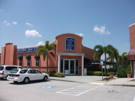


Property Detail
3696 N Wickham Rd
27-36-01-00-00007.0-0000.00
PART OF SE 1/4 OF NE 1/4 LYING E OF PB 43 PG 17 AS DESC IN ORB 4585 PGS 137 & 152 PAR 18
Storebuilding
Brevard
C2
Florida
B and X Area of moderate flood hazard, usually the area between the limits of the 100-year and 500-year floods.
5.17 AC
2024
Brevard County
2025
Orlando
064102
Palm Bay-Melbourne-Titusville, FL
55,111 SF
NEARBY LISTINGS FOR SALE OR LEASE
DEMOGRAPHICS near 3696 N Wickham Rd
1 mile
3 mile
5 mile
2025 Total Population
7,994
51,204
104,759
2030 Population
8,589
54,382
112,181
Pop Growth 2025-2030
+ 7.44%
+ 6.21%
+ 7.08%
Average Age
44
44
45
2025 Total Households
3,417
22,070
44,524
HH Growth 2025-2030
+ 6.91%
+ 5.81%
+ 6.68%
Median Household Inc
$89,709
$83,178
$89,544
Avg Household Size
2.30
2.30
2.30
2025 Avg HH Vehicles
2.00
2.00
2.00
Median Home Value
$384,763
$379,335
$410,245
Median Year Built
1990
1989
1986
Nearby Places
Map Layers
Map Styles
 Street
 Aerial
Layers
 Traffic
 Biking
Places
Listings with unknown addresses are not visible on the map
- Restaurants
- Banks
- Shops
- Fitness
- Groceries
PUBLIC TRANSPORTATION
AIRPORT
Melbourne Orlando International
Drive
Walk
Distance
Melbourne Orlando International
17 min
7.7 mi
Nearby Properties
Address
Land Use
TOTAL SIZE
Lot Size
Zoning
Address
Land Use
TOTAL SIZE
Lot Size
Zoning
676,548 SF
117.62 AC
I1
Address
Land Use
TOTAL SIZE
Lot Size
Zoning
438,381 SF
25.66 AC
R2
Address
Land Use
TOTAL SIZE
Lot Size
Zoning
363,826 SF
25.61 AC
RA
Address
Land Use
TOTAL SIZE
Lot Size
Zoning
236,982 SF
39.26 AC
EU2
Address
Land Use
TOTAL SIZE
Lot Size
Zoning
360,921 SF
85.76 AC
R2
Address
Land Use
TOTAL SIZE
Lot Size
Zoning
269,111 SF
21.79 AC
PUD
Address
Land Use
TOTAL SIZE
Lot Size
Zoning
328,357 SF
34.11 AC
I1
Address
Land Use
TOTAL SIZE
Lot Size
Zoning
296,436 SF
28.05 AC
Address
Land Use
TOTAL SIZE
Lot Size
Zoning
216,446 SF
14.09 AC
R2
Address
Land Use
TOTAL SIZE
Lot Size
Zoning
222,779 SF
22.58 AC
R2
Address
Land Use
TOTAL SIZE
Lot Size
Zoning
188,237 SF
13.97 AC
R2
Address
Land Use
TOTAL SIZE
Lot Size
Zoning
253,120 SF
16.02 AC
R2
Address
Land Use
TOTAL SIZE
Lot Size
Zoning
198,876 SF
64.32 AC
M1
Address
Land Use
TOTAL SIZE
Lot Size
Zoning
188,093 SF
13.11 AC
R2
Address
Land Use
TOTAL SIZE
Lot Size
Zoning
227,172 SF
26.78 AC
BU1
Address
Land Use
TOTAL SIZE
Lot Size
Zoning
131,585 SF
10 AC
R2
Address
Land Use
TOTAL SIZE
Lot Size
Zoning
218,739 SF
11.23 AC
R2
Address
Land Use
TOTAL SIZE
Lot Size
Zoning
200,878 SF
16.41 AC
R2
Address
Land Use
TOTAL SIZE
Lot Size
Zoning
132,340 SF
14.58 AC
R2
Address
Land Use
TOTAL SIZE
Lot Size
Zoning
142,230 SF
13.33 AC
C1
Address
Land Use
TOTAL SIZE
Lot Size
Zoning
102,972 SF
18 AC
R2(6)
Address
Land Use
TOTAL SIZE
Lot Size
Zoning
97,430 SF
51.89 AC
BU1
Address
Land Use
TOTAL SIZE
Lot Size
Zoning
171,773 SF
8.02 AC
R2
Address
Land Use
TOTAL SIZE
Lot Size
Zoning
184,197 SF
12 AC
R1AAA
Address
Land Use
TOTAL SIZE
Lot Size
Zoning
87,681 SF
11.53 AC
I1
Address
Land Use
TOTAL SIZE
Lot Size
Zoning
147,729 SF
9.32 AC
I1
Address
Land Use
TOTAL SIZE
Lot Size
Zoning
145,250 SF
10.85 AC
CR1A
Address
Land Use
TOTAL SIZE
Lot Size
Zoning
111,696 SF
13.09 AC
CCP
Address
Land Use
TOTAL SIZE
Lot Size
Zoning
120,600 SF
2.76 AC
Address
Land Use
TOTAL SIZE
Lot Size
Zoning
145,565 SF
15.97 AC
CP
The World's #1 Commercial Real Estate Marketplace
Connect with us
© 2026 CoStar Group
The information above has been obtained from sources believed reliable. While we do not doubt its accuracy we have not verified it and make no guarantee, warranty or representation about it. It is your responsibility to independently confirm its accuracy and completeness. Any projections, opinions, assumptions, or estimates used are for example only and do not represent the current or future performance of the property. The value of this transaction to you depends on tax and other factors which should be evaluated by your tax, financial, and legal advisors. You and your advisors should conduct a careful, independent investigation of the property to determine to your satisfaction the suitability of the property for your needs.